Saint Martin
| Native name: Sint Maarten (Dutch) Saint-Martin (French) Sobriquet: The Friendly Island |
|
|---|---|
 |
|
 |
|
| Geography | |
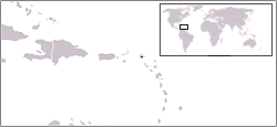
| Location | Caribbean Sea |
| Archipelago | Leeward Islands, Lesser Antilles |
| Area | 87 km2 (33.6 sq mi) |
| Highest elevation | 414 m (1,358 ft) |
| Highest point | Pic Paradis |
| Country | |
|
Kingdom of the Netherlands
|
|
| Constituent country | |
| Island territory | |
| Largest city | Philipsburg (pop. 1,338) |
|
France
|
|
| Overseas collectivity | |
| Largest city | Marigot (5,700) |
| Demographics | |
| Population | 74,852 (as of January 1, 2007) |
| Density | 860 /km2 (2,230 /sq mi) |
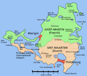
Saint Martin (French: Saint-Martin; Dutch: Sint Maarten) is an island in the northeast Caribbean, approximately 300 km (186 miles) east of Puerto Rico. The 87 km2 island is divided roughly 60/40 between France (53 km2)[1] and the Netherlands Antilles (34 km2)[2]; it is the smallest inhabited sea island divided between two nations, a division dating to 1648. The southern Dutch half comprises the Eilandgebied Sint Maarten (Island Territory of St. Maarten) and is part of the Netherlands Antilles. The northern French half comprises the Collectivité de Saint-Martin (Collectivity of St. Martin) and is an overseas collectivity of France.
On January 1, 2007 the population of the entire island was 74,852 inhabitants, 38,927 of whom lived on the Dutch side,[3] and 35,925 on the French side.[4]
Collectively, the two territories are known as "St-Martin / St Maarten". Sometimes SXM, the IATA identifier for Princess Juliana International Airport (the island's main airport), is used to refer to the island.
Contents |
Geography

Saint Martin has a land area of 87 km2, 53 km2 of which is under the sovereignty of France,[1] and 34 km² under the sovereignty of the Netherlands.[2]
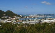
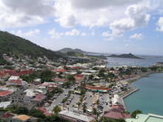
The main cities are Philipsburg (Dutch side) and Marigot (French side). While the city with the highest population, Marigot, lies on the French side, the Dutch side is more highly populated.
The highest hilltop is the Pic Paradis (424 m) on center of a hill chain (French side). There is no river on the island, but many dry guts. Hiking trails give access to the dry forest covering tops and slopes.
The average yearly air temperature is 27 °C (min 17 °C, max 35 °C) and sea surface temperature 26.4 °C. The total average yearly rainfall is 995 mm, with 99 days of thunder.
The island is south of Anguilla, separated from the British territory by the Anguilla Channel. Saint Martin is northwest of Saint Barthélemy, separated from the French territory by the Saint-Barthélemy Channel.
History
Timeline
- Circa AD 800 — Settled by Arawak Indians who arrived from South America; given the name Soualiga, or Land of Salt.
- November 11, 1493 — Claimed for Spain by Columbus, named Isla de San Martín upon his arrival.
- 1624 — Some French cultivate tobacco in French Quarter.
- 1631 — Dutch small colony on Groot Baai ("Great Bay") to collect salt.
- 1633–1647 — Spanish army from Puerto Rico build the first military fort, but after a few years destroy it and abandon the island forever.
- March 23, 1648 — Divided into French (north) and Dutch (south) zones (Dutch zone subordinate to Sint Eustatius until 1672).
- 1679–1689 — French occupy entire island.
- 1689–1792 — Dutch zone under Dutch West India Company administration.
- 1690–1699 — English occupy entire island.
- 1699–1702 — French occupy entire island.
- 1703–1717 — Dutch occupy entire island.
- February 24, 1779 – February 3, 1781 — French occupy entire island.
- February 3, 1781 – November 26, 1781 — British occupy entire island.
- May 18, 1793 – April 5, 1794 — Dutch administer entire island.
- April 29, 1795 – March 24, 1801 — French occupy entire island.
- March 24, 1801 – December 1, 1802 — British occupy entire island.
- July 9, 1810 — Annexed along with the Netherlands by France (not effected).
- 1810–1816 — British occupy entire island.
- 1816 — French and Dutch zones restored.
- 1919 – April 1, 1983 — Saba, Sint Eustatius and Sint Maarten united as Netherlands Windward Islands.
- 1936 — Dutch side officially adopts the Dutch spelling Sint Maarten.
- September 4, 1960 — Hurricane Donna hits the island causing extensive damage.
- September 5, 1995 — Hurricane Luis devastates the island.
- June 23, 2000 — Referendum supports a "status aparte" as a separate entity within the Kingdom of the Netherlands by 68.9%.
- December 7, 2003 — The population of the French part of the island votes in favour of secession from Guadeloupe in order to form a separate overseas collectivity (COM) of France.
- November 2, 2006 — Sint Maarten and Curaçao sign agreement with the Netherlands on "status aparte".
- February 22, 2007 — French side becomes a separate overseas collectivity (COM).
- October 10, 2010 — Date set for dissolution of Netherlands Antilles.[5]
Details
In 1493, Christopher Columbus embarked on his second voyage to the New World. According to legend, Columbus sighted and perhaps anchored at the island of Saint Martin on November 11, 1493, the feast day of Saint Martin of Tours. In his honor, Columbus named the island San Martin. This name was translated to Sint Maarten (Dutch), Saint-Martin (French) and "Saint Martin" in English.
At Columbus's time, St. Martin was populated, if populated at all, by Carib amerindians. The former Arawaks had been chased by the Caribs coming from the North coast of South America a short time before the arrival of the Spaniards who followed in Columbus' wake. The English word cannibal is derived from the Spanish pronunciation for Carib. The Arawaks were agricultural people who fashioned pottery and whose social organization was headed by hereditary chieftains who derived their power from personal deities called zemis.
The Caribs' territory was not completely conquered until the mid-17th century when most of them perished in the struggle between the French, English, Dutch, Danes and Spanish for control of the West Indies. The Dutch first began to ply the island's ponds for salt in the 1620s. Despite the Dutch presence on the island, the Spaniards recaptured St. Martin in 1633 and, one year later, built a fort (now Ft. Amsterdam) and another artillery battery at Pointe Blanche to assert their claim and control access to Great bay salt pond. The Spaniards introduced the first African slaves to the area in the 16th century but the main influx of African slaves took place in the 18th century with the development of Sugarcane plantations by the French Protestants and some Dutch Jews. Slavery was abolished in the first half of the 19th century, whereupon on some of their territories the British imported Chinese and East Indians to take the place of slaves. Thus, St. Martin and the other islands are populated by a mixture of Amerindian, European, African, Indians and Asian peoples. West Indian cultures such as in St. Martin are, consequently, exceedingly rich and varied.
Border division
On March 23, 1648, France and the Dutch Republic agreed to divide the island between their two nations, so they signed the Treaty of Concordia.
Folklore surrounds the history of the once ever-changing border division between St. Martin and Sint Maarten, and a popular story among locals narrates that "to divide the island in two sections, [in 1648] the inhabitants were told to choose two walkers, one chosen by the French-dominated community and the other one by the Dutch-dominated community, who were put back to back in one extreme of the island, making them walk in opposite directions while stuck to the litoral line, and not allowing them to run. The point where they eventually met was set as the other extreme of the island, and the subsequently created line was chosen as the frontier, dividing Saint-Martin from Sint Maarten. Seemingly, the French walker had walked more than his Dutch counterpart (each one earned his land, respectively, 54 km² and 32 km²). As the first man chose wine as his stimulant prior to the race, while the latter chose beer, the difference between such beverages' lightness was said to be the cause of the territorial differences by French locals, while Dutch locals tended to blame the French walker for running."[6]
In 1994, the Kingdom of the Netherlands and France signed the Franco-Dutch treaty on Saint Martin border controls, which allows for joint Franco-Dutch border controls on so-called "risk flights". After some delay, the treaty was ratified in November 2006 in the Netherlands, and subsequently entered into force on 1 August 2007. Though the treaty is now in force, its provisions are not yet implemented as the working group specified in the treaty is not yet installed.
St. Martin received the ISO 3166-1 code MF in October 2007.[7] The status of the Dutch side was due to change to a country within the Kingdom of the Netherlands in December 2008, but this has been postponed to 10 October 2010.[5] It is expected the Dutch part will also get its own ISO 3166-1 code when the status change goes into effect.
Demographics
On January 1, 2007 the population of the entire island of Saint Martin was 74,852 inhabitants, 38,927 of whom lived on the Dutch side of the island,[3] and 35,925 on the French side of the island.[4] Although half-French and half-Dutch, English is the dominant language. A local dialect is spoken informally on both sides of the island.[8] In addition there is an average of 1,000,000 tourist visitors per year.
Culture and tourism
St. Martin's Dutch side is known for its festive nightlife, beaches, jewelry, exotic drinks made with native rum-based guavaberry liquors, and plentiful casinos. The island's Saint Martin|French side is known for its nude beaches, clothes, shopping (including outdoor markets), and rich French and Indian Caribbean cuisine. English is the most commonly spoken language along with a local dialect. The official languages are French for Saint Martin, and both Dutch and English for Sint Maarten. Other common languages include various French-based reoles (spoken by immigrants from other French Caribbean islands), Spanish (spoken by immigrants from the Dominican Republic), and Papiamento (spoken by immigrants from Aruba, Bonaire and Curacao).
The island is home to accommodations including hotels, villas, and timeshares, many of which are privately available for rent or sale.
Rental cars are the primary mode of transportation for visitors staying on island. If any driving is expected off the major roads (such as to some of the more secluded beaches), a 4-wheel drive is recommended. Traffic on the island, however, has become a major problem; long traffic jams between Marigot, Philipsburg and the airport are common.
Because the island is located along the intertropical convergence zone, it is occasionally menaced by tropical storm activity in the late summer and early fall.
The island is widely known for its hundreds of gourmet (and more moderately priced) restaurants on both sides of the island.
Neighbouring islands include Saint Barthélemy (French), Anguilla (British), Saba (Netherlands Antilles), Sint Eustatius "Statia" (Netherlands Antilles), Saint Kitts and Nevis (Independent, formerly British). With the exception of Nevis, all of these islands are easily visible on a clear day from St. Martin.
Shopping
Shopping on St Maarten and Saint Martin offers duty-free goods in numerous boutiques. Popular goods include local crafts & arts, exotic foods, jewelry, liquor, tobacco, leather goods, as well as most designer goods. Most often the designer goods are offered at significant discounts, often up to 40% lower than US retail prices.
Saint Martin uses the euro as its currency, while Sint Maarten is currently outside the Eurozone and uses the Netherlands Antillean guilder, pegged at 1.79 per United States dollar. It is unknown if Sint Maarten will shift to the euro some time after the Netherlands Antilles dissolves. Almost every store on the island also accepts the United States dollar, although sometimes a more expensive exchange rate is used (even 1 to 1 is no exception).
Transportation
Border checks
Neither side of the island is part of the Schengen Area; full border checks are performed when travelling between the island and Europe. There are rarely checks at the border between the two sides of the island. The Franco-Dutch treaty on Saint Martin border controls is being implemented to harmonize external checks at the two main airports.
Airports
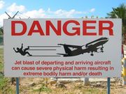
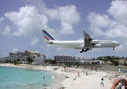
The island is served by many major airlines that bring in large jet aircrafts, including Boeing 747s, Airbus A340s, and McDonnell Douglas MD-11s carrying tourists from across the world on a daily basis. The short length of the main runway at Princess Juliana International Airport, and its position between a large hill and a beach causes some spectacular approaches. Aviation photographers flock to the airport to capture pictures of large jets just a few metres above sunbathers (who are often blown away by the jet blast if they are standing in its path) on Maho Beach. [9] There is a small airport on the French side of the island at Grand Case, L'Espérance Airport for small jet and propeller planes serving neighbouring Caribbean islands. Due to its location, Grand Case-Esperance Airport frequently suffers from heavy fog during the hurricane season.
See also
- List of divided islands
- Saint Martin (France)
- Sint Maarten
- History of St. Martin
- List of Sint Maarten governors
- Culture of St. Martin
- O sweet Saint-Martin's Land (bi-national song/anthem of Saint-Martin/Sint-Maarten)
- Région Guadeloupe et Saint Martin (Scouting)
- Princess Juliana International Airport
References
- ↑ 1.0 1.1 INSEE, Government of France. "Démographie des communes de Guadeloupe au recensement de la population de 1999". http://www.insee.fr/fr/themes/tableau.asp?reg_id=26&ref_id=AMTOP005. Retrieved 2009-01-27. (French)
- ↑ 2.0 2.1 Central Bureau of Statistics Netherlands Antilles. "Area, population density and capital". http://central-bureau-of-statistics.an/area_climate/area_a1.asp. Retrieved 2009-01-27.
- ↑ 3.0 3.1 Central Bureau of Statistics Netherlands Antilles. "Population per Island, January 1st". http://central-bureau-of-statistics.an/population/population_b2.asp. Retrieved 2010-01-30.
- ↑ 4.0 4.1 INSEE, Government of France. "Populations légales 2007 pour les départements et les collectivités d'outre-mer". http://www.insee.fr/fr/ppp/bases-de-donnees/recensement/populations-legales/france-departements.asp?annee=2007. Retrieved 2010-01-30. (French)
- ↑ 5.0 5.1 St. Maarten-St. Martin - Consensus, but no date set for new status
- ↑ Pérez, Abón Satur (Chief Editor) (1980). Nueva Geografía Universal, Tomo IX, América. (New Universal Geography, Volume IX, America). Promexa. p. 19. ISBN 8471131307.
- ↑ ISO 3166-1 Newsletter. Assignment of code elements for Saint-Barthélemy and Saint-Martin and update of France and other French Territories
- ↑ Holm (1989) Pidgins and Creoles, vol. 2
- ↑ Aviation Photos: Philipsburg / St. Maarten - Princess Juliana (SXM / TNCM), Airliners.net.
External links
- General information
- Saint Martin entry at The World Factbook
- Saint Martin at the Open Directory Project
- Wikimedia Atlas of Saint Martin
- News and media
- The Daily Herald daily newspaper from St. Maarten
- LE FAXinfo daily newspaper from Saint Martin (in French)
- Travel
- Dutch St. Maarten official Tourist Bureau
- French Saint Martin official Tourist Office
- Princess Juliana International Airport, St. Maarten official site
- Saint Martin travel guide from Wikitravel
- Other
- Birds of St. Martin, by Eric Dubois-Millot, Action Nature.
|
|||||||||||||||||||||||||||||||||||||
|
|||||||||||||||||||||||||